

Why Is Carter Lake, Iowa Located on the Nebraska Side of the Missouri River?
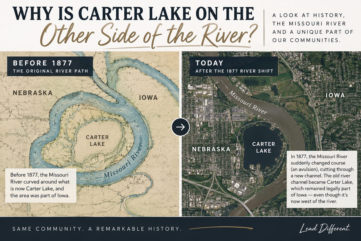
In March 1877, a flood suddenly shifted the Missouri River's channel about 1.25 miles to the southeast, cutting off a bend of the old riverbed and leaving what's now Carter Lake, Iowa stranded on the west side of the new river — the Nebraska side. In 1892, the U.S. Supreme Court ruled in Nebraska v. Iowa that Carter Lake stayed part of Iowa anyway, because the river had moved suddenly rather than gradually. That's why you have to drive through Nebraska to reach an Iowa city today.
By Jamie Leaders, Broker/Owner | September 23, 2026
If you've ever driven to Eppley Airfield and noticed a "Welcome to Iowa" sign right before you get to a Nebraska airport, you've run into one of the strangest little geography quirks in the entire country. It's a fun one, and it's one I get asked about often enough that it's worth writing down properly.
The Flood That Moved a State Line
Rivers move. That's normal, and state boundaries drawn along a river are generally designed to move with it — a legal concept called "accretion," where gradual erosion and deposit slowly shift the river channel, and the boundary shifts along with it.
What happened here wasn't that. In March 1877, a flood on the Missouri River caused the channel to jump — not creep, jump — to a new path about 1.25 miles southeast of where it had been. The old bend of river got cut off entirely and became a stagnant oxbow lake, which was eventually named Carter Lake. The land that used to sit on the Iowa side of the river was now, geographically, on the Nebraska side of the new channel.
Why the Supreme Court Got Involved
Naturally, this created a real dispute. If the river is the boundary, and the river just moved, does the boundary move with it? Nebraska and Iowa argued over exactly this for years, and it eventually landed at the U.S. Supreme Court.
In 1892, the Court ruled in Nebraska v. Iowa, 143 U.S. 359, that the land stayed part of Iowa. The key legal distinction: when a river shifts gradually (accretion), the boundary moves with it. When a river shifts suddenly, in a single dramatic event — legally called "avulsion" — the boundary stays put at its old location, even though the river itself has moved on. Because the 1877 flood was a sudden channel jump rather than a slow drift, the original boundary line held, and Carter Lake stayed Iowa territory, marooned on the far side of a river that no longer ran past it.
What This Looks Like on the Ground Today
Practically speaking, Carter Lake now sits surrounded by Nebraska on most sides, wrapping around the south and west edges of Eppley Airfield — Omaha's main airport. If you're coming from most directions, getting to Carter Lake, Iowa means driving through Omaha, Nebraska first. It's a strange, genuinely fun bit of trivia: an Iowa city you can only comfortably reach by crossing into Nebraska.
It's also a good reminder of just how tightly connected this whole metro really is. Council Bluffs, Omaha, and Carter Lake function as one interconnected community day to day, even though a state line — and, in this one specific spot, a very unusual one — runs through the middle of it.
Why Local Quirks Like This Matter
I bring stuff like this up because knowing a market means more than knowing square footage and school districts — it means actually knowing the place. Carter Lake's history isn't going to change anyone's offer strategy, but it's the kind of local knowledge that comes from actually living and working here, not from pulling comps off a spreadsheet.
If you're new to the Council Bluffs/Omaha metro, or you're just the kind of person who likes knowing why your hometown is weird in this specific way, I hope this one was fun. And if you're navigating a move to (or around) this area and want someone who actually knows the ins and outs of it — river boundaries included — I'm happy to help.
Curious about other local quirks, or thinking about a move to this area? Reach out anytime — call or text me at 402.306.6255.
Frequently Asked Questions
Is Carter Lake part of Iowa or Nebraska? Carter Lake is legally part of Iowa, even though it sits geographically on the west side of the Missouri River — the same side as Nebraska. This was settled by the U.S. Supreme Court in 1892.
Why do you have to drive through Nebraska to get to Carter Lake, Iowa? Because the Missouri River shifted its channel suddenly in an 1877 flood, Carter Lake ended up on the far side of the new river from the rest of Iowa. Since it's surrounded by Nebraska on most sides today, reaching it from most directions means driving through Omaha, Nebraska first.
What is an avulsion, and why does it matter for state boundaries? An avulsion is a sudden, dramatic shift in a river's channel, as opposed to gradual erosion (accretion). Courts treat the two differently: a boundary generally moves with gradual river changes, but stays at its original location when a river shifts suddenly through avulsion — which is exactly what happened to Carter Lake in 1877.
Does Carter Lake still have an actual lake today? Yes. The oxbow lake left behind by the 1877 flood still exists and gave the city its name, sitting near Eppley Airfield in what's now the city of Carter Lake, Iowa.
Are there other places like this along the Missouri River? Yes — sudden river channel shifts have created similar boundary oddities in a few spots along the Missouri River between different states, though Carter Lake is one of the better-known examples because of how close it sits to a major airport.